
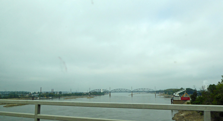
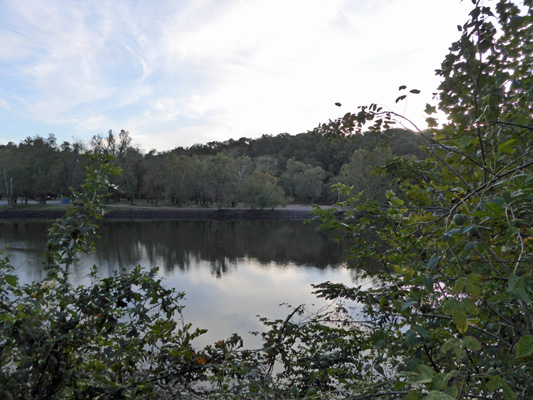
It was warm and cloudy so visibility wasn’t very good. But that’s clearly the Mississippi.
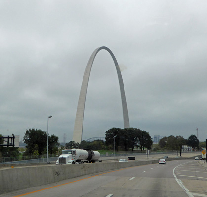
After a little jog through the surface streets in town, we picked up I-44 which took us right past the St. Louis Arch.
And then we followed I-44 for miles and miles SW across Missouri until we got off in Lebanon (east of Springfield) onto Hwy 64. We followed Hwy 64 about 12 miles NW to Bennett Spring State Park. This is a favorite fishing spot in the area and there were a remarkable number of folks camping in the main campground loop down by the springs. Instead of being crowded in among all those people, we took a nice electricity back-in spot up the hill in the trees where there were hardly any folks. The camping fee here for that sort of spot is only $21 and then they give seniors a $2 discount so we got a paved back-in spot with electricity for $19 a night. What a deal!
They have WiFi here but it only worked right next to the antenna on the shower house. But there is a nice cell tower on the hill and Walter’s phone and the hot spot worked great (especially with our booster). Walter found 16 TV stations over-the-air including two sets of PBS (which is our favorite during the week). My Virgin Mobile (Sprint network) which had worked fine in Granite City (which is in the greater metropolitan area of St. Louis) of course didn’t work 12 miles off the freeway.
It was clear and sunny by the time we got to Bennett Spring and it just got hotter as the afternoon progressed. We topped out at 89 but at least it wasn’t as humid as it had been in St. Louis.
It rained in the night and was down to 61 when we got up. The weather folks on the TV had said that the temperature would sink as the day progressed so once it had stopped raining we went out to take our hike. It had sunk to 56 already so I even wore my raincoat!
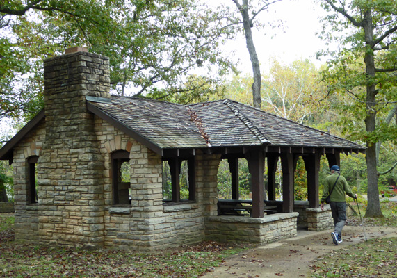
We drove down to the south end of the park and the source of the springs to take the Spring Trail which starts at a picnic/playground area up on a rise above the spring. The CCC built a lot of structures here in the 1930’s including this lovely picnic shelter.
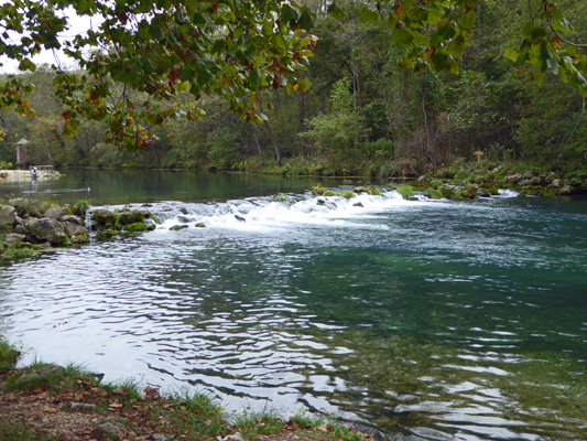
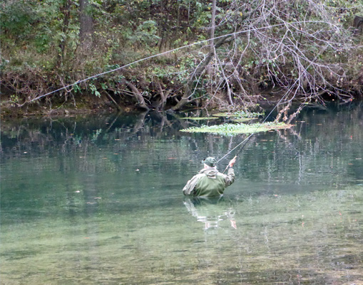
The trail follows what they call the Spring Branch as it flows towards the Niangua River. The spring produces 100 million gallons of water a day so the Spring Branch moves along at a nice gentle clip. They stock it with trout on a daily basis from March 1st to October 31 (fishing season) so there are tons of folks fishing in the clear clean water. The branch tumbles over a little artificial falls.
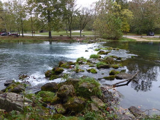
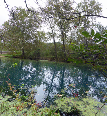
We saw fish all along our side of the branch. It turns out you can’t fish from the trail side and the fish must know it because they hang out more there. The spring end of the branch is designated fly fishing only so the fly fishermen can easily cast across the branch to where the fish were. The water is an interesting teal color in the deeper areas.
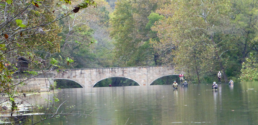
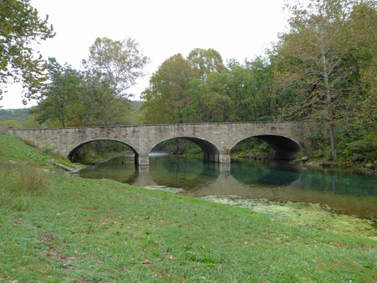
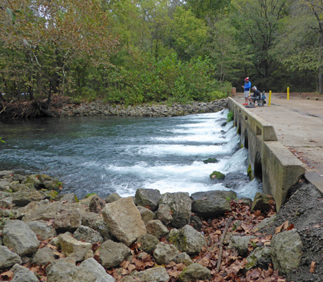
Just before you get to the fish hatchery there’s a great view of a bridge that was one of the CCC projects. There’s a dam here and the fishermen were standing in the water in front of it and on top of it.
We saw tons of fish but we didn’t see anyone catch anything. They said that the fish had been biting in the morning but that the water changed as the wind shifted and now they weren’t biting.
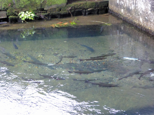
We walked past a portion of the fish hatchery and I managed to get a decent shot of some of the fish hanging out right at the exit. They got smaller as we went along so my guess is that these guys would be released the next day.
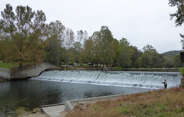
We walked on and I got this photo of the water rushing over the dam.
And a shot of the bridge from this side of the dam.
We decided to make a loop of it and walked over the bridge and along the paths back up the branch. Along the way we got a nice view of the little falls.
I love that teal color of the deeper water.
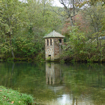
The CCC built the Gauge House which keeps track of the water flow from the springs.
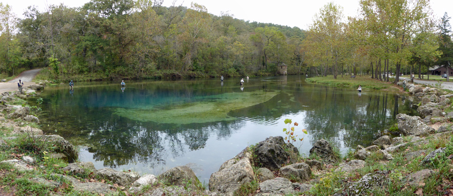
The springs come out of the hillside through a 10 foot high, 20 foot wide steeply (downward) inclined passage. It flows into a 50 foot wide basin that had fishermen in it (just like everywhere else) when we returned.
Having completed the loop we drove on back towards the campground and stopped at the Whistle Bridge so I could take a photo. It’s called this because the row of culverts it sits on looks like a whistle.
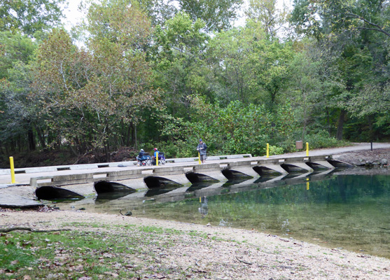
There was a fly fisherman just up stream from here who was standing chest deep in the water. Clearly there’s a steep drop off here.
On the other side of the bridge the water come out in a nice series of cascades.
The temperature continued to drop as the day wore on and it began to rain too. We were glad we’d done our walk when we did since rain and 50 degrees might have kept us from going out.
It got down to 46 in the night but we were snug and warm inside. We broke camp and headed back south on Hwy 64 to I-44 where we headed southwest across Missouri. Just before Joplin, MO we turned south on I-49 and then got off on Hwy 60 and headed west across the Oklahoma border. There was lots of traffic on this little highway because folks were avoiding I-44 which is a toll road. We followed Hwy 60 along the edges of Grand Lake and then turned south on Hwy 82 to Langley and then made a few twists and turns to end up at Grand Lake State Park Cherokee Area. Grand Lake State Park has 8 areaa along the 450 miles of coastline on Grand Lake. The Cherokee area has a number of campgrounds and we fumbled our way from the Golf Course to the the Grand Cherokee campground which has wonderful full hookup sites that are mostly pull throughs and all were paved with a big level concrete pad to park your rig on. There were no signs to tell you what to do so we drove around and picked a site that said it was available (as opposed to the ones that had the sign flipped to reserved). It was a nice side pull-through spot overlooking the river.
We set up and decided we’d go over the Park Office over by the golf course to see if we could register. The lady there was very nice and informed us that the ranger or the camp host would come by later and take our money. Okey Dokey.
We went back and made lunch and sure enough, the camp hosts came by to get us registered. This lovely full hookup site was $28 a night with our $2 discount for being seniors. Such a deal. Walter’s phone had a couple of bars and our hot spot worked great with the booster (it always helps to be in a nearly empty campground at low season). There was no TV over the air though.
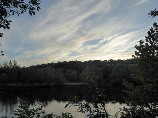
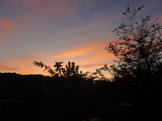
It had been cloudy for most of the drive but it cleared off late in the afternoon and eventually warmed up briefly into the 70’s. We had a window or two and the door open and it was just pleasant. In the early evening the sun sank behind the hills (yes there are still hills in this part of Oklahoma but it was much flatter than the Ozarks in Missouri) and the wispy clouds lit of the sky.
Moving just a little to avoid the bushes I got a decent shot of the river too.
I’d thought we might have a pretty good sunset with those nice clouds but most of them disappeared. Even then we got a bit of color for a little while along about 7 pm.
It was cold again that night (I sleep so much better when it’s cooler—ahhhh) and it was only 46 in the morning. We took it slow in the morning since we had no plans for a hike—there are NO trails in Grand Lake State Park. Late morning we drove into town to the hardware store (the smoke detector began to beep this morning. Time for a new battery). And then followed the signs to the Pensacola Dam. A narrow road takes you across the top of the dam and then the road continues to Disney Island, where there is yet another small campground and boat launch that is part of the state park. We stopped here to get a view of the lake.
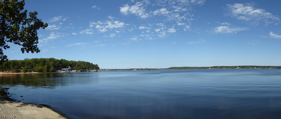
This is a HUGE long lake. It’s not that wide but it goes on and on and on. There’s lots of private waterfront property along the shoreline too.
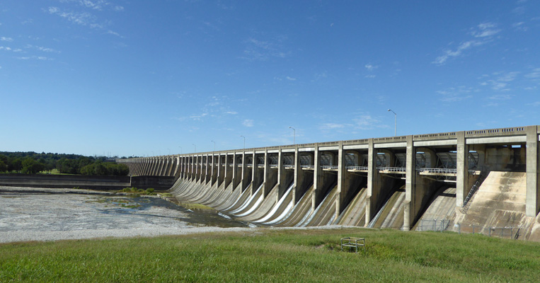
We drove back to the dam and realized just as we were beginning to cross it that there was a great place down below where we could get a view of the dam. Damn. So we stopped at the parking area on the west side of the dam where I took a photo across the lake at the face of the dam.
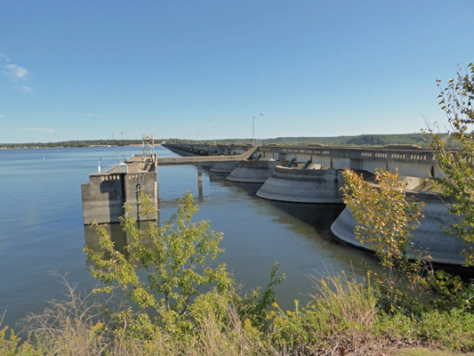
The dam is a mile long and has a hydroelectric plant on this end that feeds water down into the Grand River in front of Grand Cherokee Campground. On the other end, there are sluice gates that feed water into a tributary, I guess. There was was wide plane of eroded limestone with a bit of water flowing through it. From this side it really looks like the dam goes on forever.
Having shot this big panorama photo, we drove back over the dam one more time and back towards the campground. But instead of heading into the campground we drove past it to the end of the road where you are RIGHT at the face of the dam over by the hydro plant.
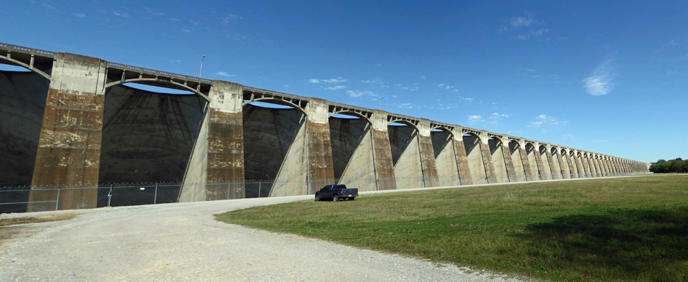
This is a weird dam. Usually there’s water down at the foot of a dam but not here. Most of the area on this side of the dam is dry with just the small river over on the west side.
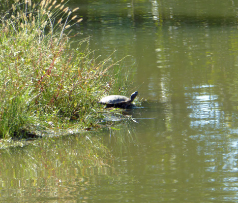
On the way back to the campground we went by a little pond and there were a whole bunch of turtles out sunning themselves. We stopped and all but one immediately dove into the water. This guy stayed long enough for me to take his picture and then he too dove in and swam away.
It was much warmer that afternoon than the weather folks had predicted. Our weather station registered up above 85 even when it was in the shade and while it wasn’t super humid it was sticky enough. It was still over 70 at 9 pm that night.
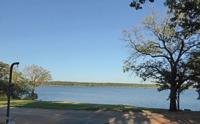
Friday October 13th, we packed up one more time and made our way to Hwy 69, a major north-south arterial. It was 80 already when we hit the road and it just kept getting hotter. We went south through Muskogee (aside from being the source of the song Okie from Muskogee there’s nothing else to say about the place) to I-40 where we headed west towards Oklahoma City. Just before we got to Oklahoma City we headed south on a blue highway to Lake Thunderbird looking for the State Park there. This area was surprisingly hilly—the road just kept going up and down and up and down. I’d left out a digit in the address when I put it in the GPS to start the day, so we turned the wrong way and drove about 5 miles before we figured it out and found a way to turn around. Then when we found the park we went into the office where they gave us a map (will wonders never cease) and sent us out to find a camping spot. We toured the Hog Creek Campground which has water and electricity hook ups but it was really noisy already—loud music. So we went back just a ways and found a spot in the Hickory Hill Campground that has premium water, sewer and electric sites. We found a nice level spot right across the road from the lake—with a view of the water from our picnic table!
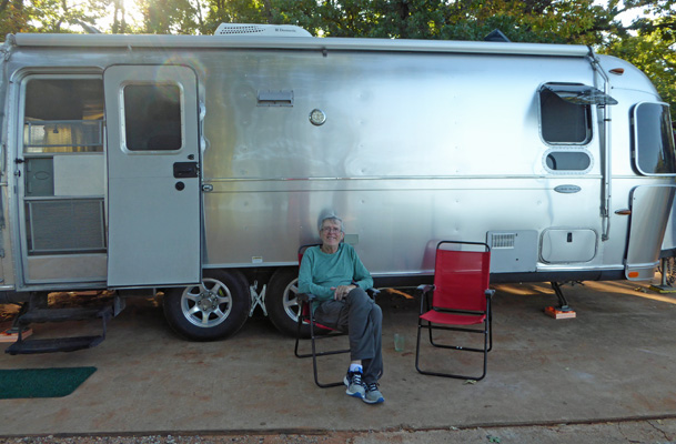
In addition, there were two Airstreams next door. There’s really nothing like seeing other Airstreams in a campground to make us feel at home. It was 87 degrees when we put the weather station out in the shade with a heat index of 91 degrees. We opened up the windows and made lunch thinking we’d eat outside. But as soon as I sat down, 5 flies alit on my sandwich. Ick. So we had lunch inside and then went out to enjoy the view and the breeze for a while—and no problems with bugs. Here’s another Red Chair photo of the domestic kind!
This is a lovely campground. The site had a concrete pad. Our hot spot worked beautifully and Walter found 13 channels over-the-air for the TV. My phone of course didn’t work because the park is over 15 miles east of Norman, OK which is too far out of town for Sprint to care. The camp host came and got our money while we were out enjoying the view. Premium water, sewer and electric sites are $30 a night but we got $2 off for being seniors so it was just $28 a night. Not bad at all especially with the nice view. Now if it weren’t so darned HOT.
Saturday October 14th, it was hotter than ever. It was 80 degrees when we got up and it just kept climbing. We closed up the trailer and turned on the air conditioning before we went to town to do our shopping and when we got back the trailer was pleasant and it was 91 degrees outside with a heat index of 97. Ugh. We rarely run the air conditioning. It’s noisy and we can usually cope with the heat. But heat plus humidity makes it worth dealing with the noise.
It stayed hot through the evening. Then just before midnight the wind came up and the dust began to fly. We closed everything up and not long after it began to rain. It blew and rained through the night and eventually the temperature began to drop. It was 56 by morning but the front had moved through and it was mostly sunny. There was a stiff breeze from the north with white caps on the lake (the wind the day before had been from the south). We went back into town and did laundry at a very nice laundromat (Hollywood Laundry) which had nice fast free WiFi.