
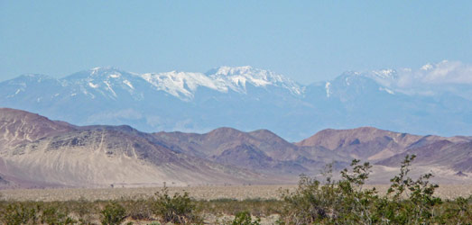
As we drove towards Death Valley north of Baker (home of the worlds largest thermometer and nothing much else) we stopped along the road to change drivers. It was a crystal clear day and you could see the Panamint range in the distance to the north. Last time we came through here (in late January 2006) there was no snow on the mountains.
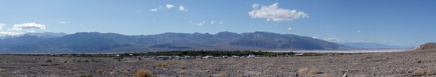
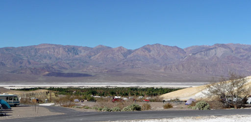
We rolled into Death Valley in the early afternoon. There are 3 campgrounds in the Furnace Creek area where the visitor's center is. Last time we camped in the Furnace Creek Campground that actually has a few trees! This year, it was full up so we had to choose between the Sunset Campground that's a big flat parking lot for big rigs (where they run their generators all day) or the Texas Springs Campground up on the hill (no generators allowed). It was an easy choice since we don't have a generator; we opted for the quiet of Texas Springs which turns out to have a great view. We stopped to use the dump station before we set up camp and I took this panorama shot. Who'd a thought you could have this great a view from the sanitary facilities? The huddle of RV's at the center of the photo is the Sunset Campground. The Furnace Creek Campground is over with the trees in the background.
Click on photo to see full size view.
We set up camp and had lunch and then headed over to the Visitor's Center to get info on possible hikes and the weather forecast. There was a front coming through and the wind had started to kick up dust down in the valley. By the time we got back to camp you could see the dust rolling across the valley floor.

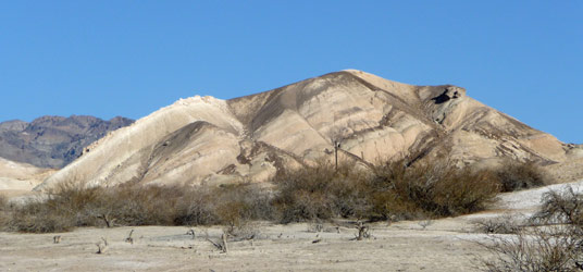
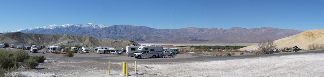
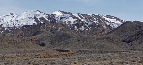
The campground itself is in a beautiful setting and I climbed up the hill to catch the late afternoon light on the hills to the east.
We had a wild night with the wind making the trailer rock and roll all night. The door mat I put outside our entry door took off in the first hour and ended up under the truck. Walter ran and fetched it and needless to say it spent most of the rest of the trip indoors.
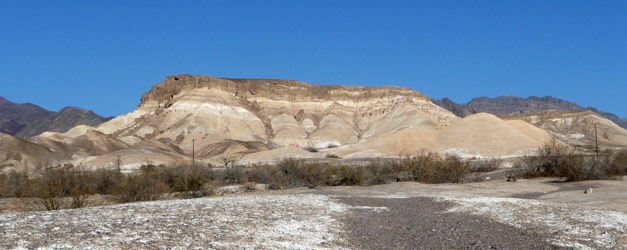
The wind finally stopped at 5am having started at about 6pm the night before. The forecast was for 50% chance of rain but the sky was clear and blue all day. After breakfast I climbed back up the hill and took this photo of the valley with no dust blowing.
Here's a panorama of the view from above the campground.
Click on the photo to see a full size version.
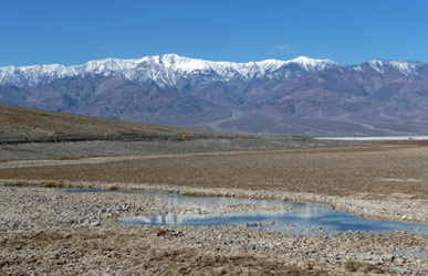
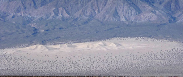
We made a picnic lunch and started out south to Badwater (the lowest point in the Valley and in North America).
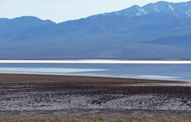
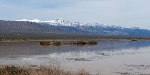
We stopped at Badwater and hiked out a ways. You can hike as far as you want out into the valley floor from here. This year if you hiked far enough you'd see water! In wet years like this one, all the run-off from rain that falls in the surrounding hills ends up as series of shallow lakes on the valley floor. Since it's the lowest place in North America it stays put since it has no place to run! You'll see more of it later on in the trip.
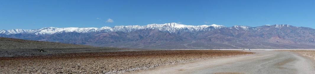
Here's a panorama I shot from the trail.
Click on the photo to see a full size version.
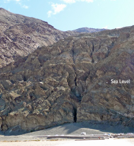
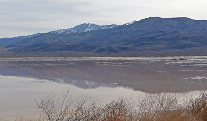
I turned around from this spot and took a shot looking south. I've marked sea level for you since Badwater is 282 ft below sea level. Dante's View (5,475 ft above sea level), where we'll go tomorrow, is high above at center of the photo. Those are cars in the parking lot at the bottom of the picture to give you a since of scale.
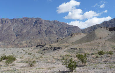
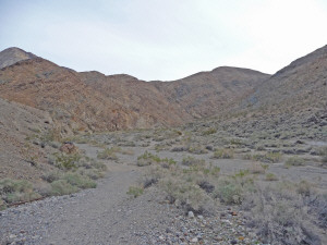
From Badwater we drove further south to an unmarked trailhead in an unmarked parking lot off the main road. We'd gotten a trail guide at the visitor's center that gave us two trails we could take from this point. One went up a slot canyon and the other was a 5 mile 1,000 ft gain hike with a waterfall at the end and the possibility of big horn sheep sightings. A waterfall in Death Valley? How could we resist? So off we went on a steady climb up a gravelly alluvial fan up into Willow Canyon.
We're going to follow the trail that goes up the side of that gray mass in front and then around the corner to the right. You can see the trail on the shelf at the base.
But first don't you want to turn around and see what's behind you looking west? Pretty swell, huh?
As we set out hiking this is the view we walked towards before turning up canyon.
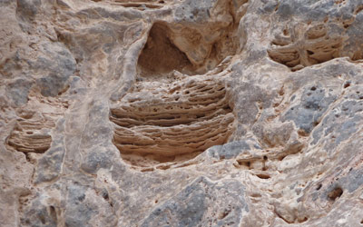
It was a long steady climb through rocks and gravel with lots of bits of greenery that had flower buds but no flowers. We were just a little early--ah well. As the canyon began to narrow we came to these wild formations up on the canyon wall with a flock of birds whirling around. If I were a bird I'd use those holes for nesting even if they do look like they're melting.
Just when I wondered whether I really wanted to slog any further through the gravel, a narrow canyon appeared on our left giving us welcome shade and compressed gravel and rocks to hike on. We hiked up canyon and found this neatly arranged set of bones on the top of a rock. We showed this photo to a ranger later and he agreed that someone had collected them and put them there--pieces of big horn sheep and other critters mostly--kinda spooky to find in a remote canyon though.

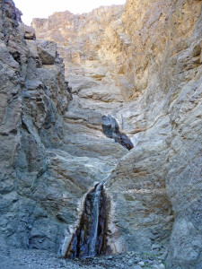
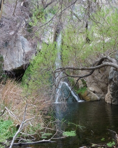
Soon we could hear the sound of running water echoing off the canyon walls. Then we came to a little stream and the first of two waterfalls we needed to climb.
After this falls the water disappeared only to reappear further up canyon with another larger waterfall. The rocks in this little fall were mossy and as I took the last big step up the falls (with the water spraying on my boot tops) I said, "If I were any shorter I don't know if I could make this." On our way back down we came across another couple who had gotten as far as this waterfall and turned back because she took one look at the falls and said it was too big a step--she was a good 4 inches shorter than I am and I'm sure she was right.
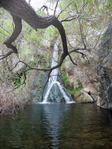
If you looked back over your shoulder at this point this was the view.
And finally at trail's end here was the waterfall.
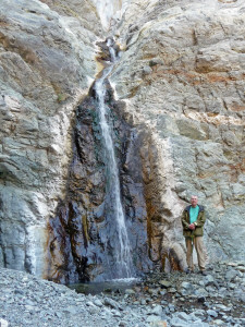
There's more canyon beyond the falls but you can't get there from here. Instead you have to come in from the other side where you'll find the willows that give the canyon their name--or so the trail guide said.
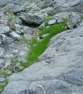
We sat for a while enjoying mother nature's air conditioning and hoping to see a big horn sheep. No luck, though we did see lots of dung. Clearly there's fodder for them here. Look at how lovely and fresh this grass is, growing in the canyon floor.
The hike back was far easier because of course it was down hill. Here's the view as you go back down the alluvial fan. There's no visible trail for any of this, you just keep crunching along.
We had our lunch on the tailgate of the truck and talked to a hiker who reported that the other hike that started here (and we had decided against)was a real dud. Once again following spirit produces a winning experience!
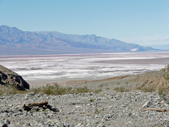
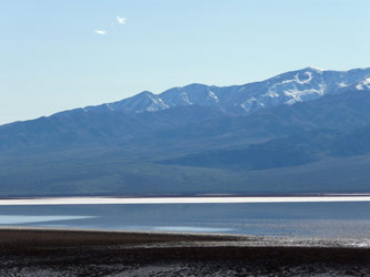
On the drive way back up valley I found a decent place to park and take some shots of one of the lakes in the valley floor.
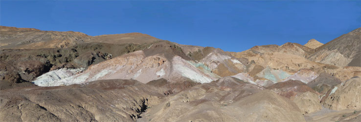
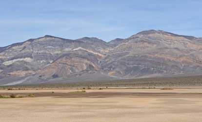
Then we did Artist's Drive out to Artist's Pallet which is a favorite place of mine. I think this stuff looks like slightly melted spumoni ice cream.
Click on the photo to see a full size version.
This big old raven was posing for the 3 van-loads of French tourists who were here and I decided I should take his photo too. Wildlife is wildlife after all.

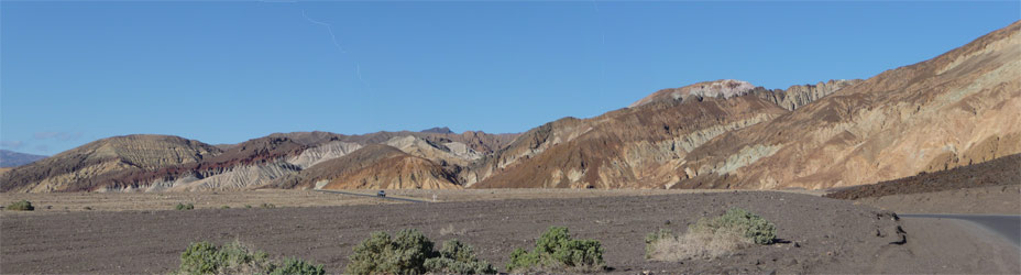
Coming off of Artists Drive the hills to the north are pretty special too.
Click on the photo to see a full size verion.
It was a pretty full day and we were both grateful to put up our feet and relax when we finally got back to the trailer.
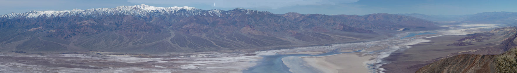
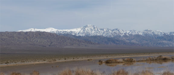
The next morning we left the trailer in the campground for the morning and drove up to Dante's View with it's HUGE view of the valley. Yes, that gray and blue smear down the middle is water! Straight down in the middle of the picture is Badwater where we were the day before.
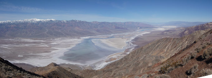
Here's another panorama with a better view of the Panamint Mountains to the west with their huge alluvial fans leading down into the valley. If you scroll right, you can also see how the water winds it's way up valley into the distance. Click on the photo to see a full size version.
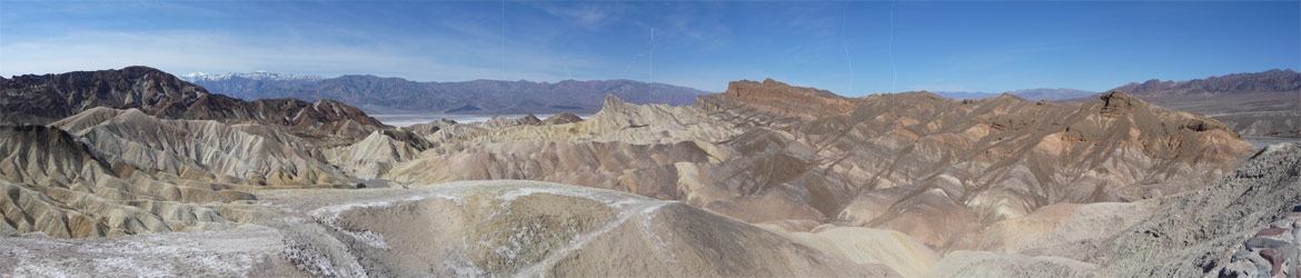
There was a large group of students from Fresno State University listening to 2 professors lecture about the valley. It was all I could do not to settle in and listen to the whole thing! Instead we drove back down the mountain to Zabrinskie Point, one of my favorite view points in all of Death Valley.
This is the view from the north to west. You can hike down into the canyons below and out into the main valley if you want. It's an 8 mile loop. Click on the photo to see a full size version.
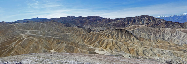
Here's the view to the south. There are canyons in amongst this golden rock where you can hike. And there's even a "road" through 20 mule team canyon that we drove last time we were here. This is NOT a drive for a regular car. You need at least a pick up and 4 wheel drive would be better. Click on the photo for a full size version.
From here we stopped of at the Visitor's Center and used their WiFi to download our email. There's no cell phone service in the valley but there are a couple of WiFi hot spots which were useful for tracking the weather for the next leg of our trip.
We hooked up the trailer and drove north through the valley to Stovepipe Wells. The campground here is really just a big parking lot but it we found a spot with a nice view of the sand dunes and mountains to the east and the Panamints to the west. We had lunch and then opted to drive west up into the Panamints since we didn't get out that way the last time we were here.
The road climbs steadily as you go west until you come to Towne Pass at 4,956 ft.
Then it descends sharply to Panamint Springs. To the north you can see the Panamint Dunes.
To the northeast there are wonderful striated mountains.
The Panamint valley is a small version of Death Valley and it too had standing water. In fact when I walked along the water-filled roadside ditch to take these photos some critter startled me by jumping into the water!
This is looking east towards the Panamints.
Here's one of my reflection photos--you know I'm a bit obsessed with these and take them whenever I can.
And this is west towards the Inyo Mountains. Beyond them are the Sierra Nevadas.
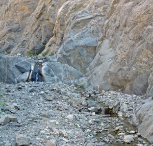
We drove further west into the Inyo's and then took a bumpy gravel road out to the trailhead to Darwin Falls. Yes, another waterfall! It turns out that there are 2 year-round waterfalls in Death Valley and we're now going to go and bag the second one! It's only a two mile hike round trip but it's rocky and has lots of stream crossings so wear your boots.
It's hard to believe looking at the start of the hike that there'll be water let alone a waterfall.
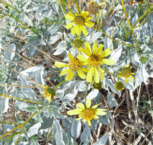
But as we went further into the canyon flowers started to appear. There were Panamint Daisies (Enceliopsis covillei) with gorgeous grey foliage.
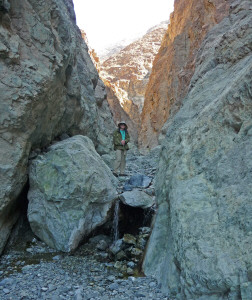
And after climbing over lots of rocks (both dry and wet) and fording the stream countless times we came at last to the Darwin Falls.
We waded across the creek one more time and I stood out on a log to take this photo.
It's a very sweet little waterfall and worth the hike.
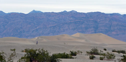
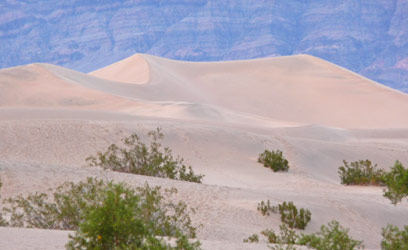
It was nearing sunset when we got back to Stovepipe Wells, the perfect time to photograph the nearby Mesquite Flats Sand Dunes.
The dunes aren't soft sand like beach dunes. Instead it's very fine, hard packed sand that really pretty easy to walk on.
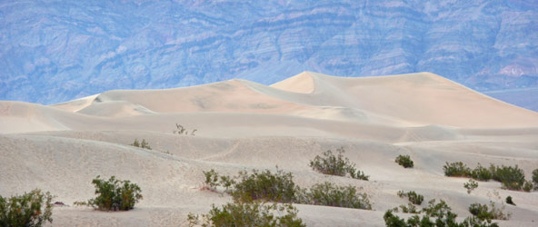
In this shot you can see the Amargosa Range in the background. The person in the foreground gives you a sense of the scale of these dunes.
As sunset drew near and I climbed further into the dunes they turned a nice pink color.
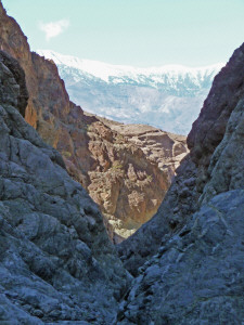
The next day we drove north to Titus Canyon for a sort of 'once in a lifetime' hike. Normally, Titus Canyon is open one-way to high clearance 4-wheel drive vehicles. They come roaring down the canyon from the east making hiking in the canyon a little dicey and noisy. Because of heavy rains there were two sections of the road that were closed so the west portion of the canyon wasn't open to cars but was still open to hikers--a perfect time to hike the canyon. For most of our time in the canyon we had the place to ourselves.
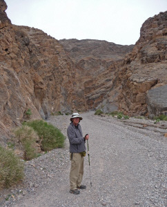
Here's Walter at the mouth of the canyon as we started out.
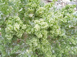
There were flowers in bloom in the canyon. Starting with this desert holly (Atriplex hymenelytra). Pretty weird looking stuff, huh?
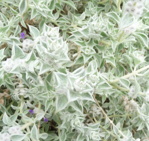
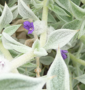
And Death Valley Sage (Salvia funerea). It was great fun to find the pretty little purple flowers in amongst the fuzzy white leaves.
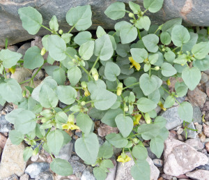
And ground cherries (Physalis crassifolia) which are a close relative of the tomatillo.
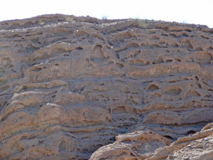
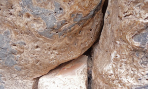
The Titus Canyon Narrows are a display of geologic wonder. There are all sorts of strange crystal structures embedded in the walls. This looked like there was a piece of agate that had been polished down in the middle of the crack.
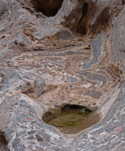
And this swirling rock led to a little pothole of water.
And then there was this fun honeycombed rock.
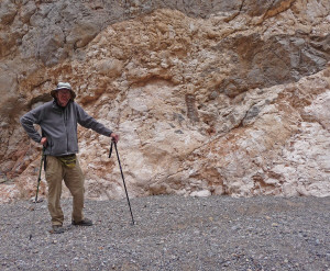
Here's Walter with a whole wall of strange stuff and holding both of our hiking sticks.
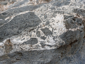
But best of all was a wall of this black and white stuff that looked like the inspiration for native people's rock art.
The road goes steadily up hill for 27 miles but we turned around after about a mile and a half when the canyon widened out at the end of the narrows and began to be kind of boring. We stopped and looked at more crystals on the way back and Walter caught me with a good case of hat hair!
We drove back to Stovepipe Wells and had lunch. Then in the afternoon took showers at the small motel there. You pay $2 and get access to their pool house where there's hot showers--pure heaven. Then we picked up our email and checked the weather on the coast using their WiFi. Since the forecast was for showers the next day and then clearing we opted to take it slow going to the coast.
The next morning we hooked up the trailer and made our way back through the Panamints and then south through the Panamint Valley to Red Rock State Park just north of Mojave. This is a great little park that gets heavy use on the weekend but during the week there was basically no one there. We picked out our site and by the time we had paid our money it was pouring. The rain turned to hail while we ate our lunch and we wondered whether we'd be cooped up inside all afternoon. Never fear. The sun came out, the big puddles drained away and I went out to read my book in a camp chair in the sun!
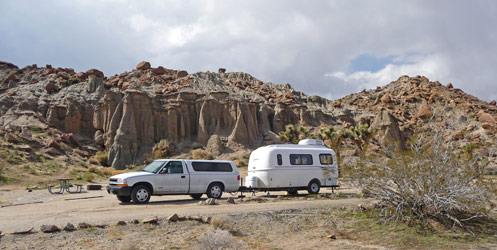
Here's our campsite from two different angles. It's amazing to me that they let people camp right in amongst these amazing formations.
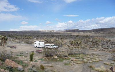
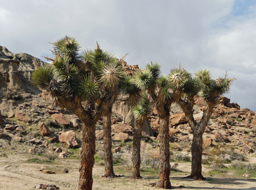
The park is at 2,600 feet so it's high desert and home to Joshua Trees. This little grove was right outside the trailer.
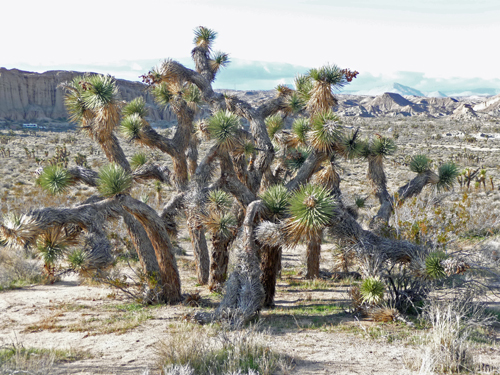
While this old guy was further off in the valley.
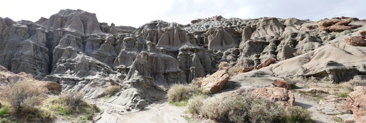
When it looked like the rain was really over we set off for a hike. First we had to walk past these wonderful 'temples' of rock. Doesn't it look like some giant children have been at work building castles by dribbling wet sand through their fingers? Click on the photo to see a full size version.
Then we began to hike up the ridge where the whole valley spread out before us.
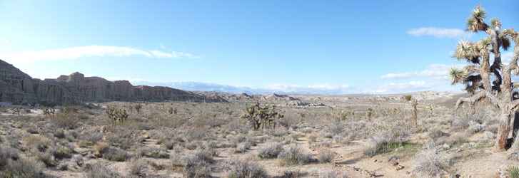
We got to the top of the ridge and the view just got better. Click on the photo for a full size version.

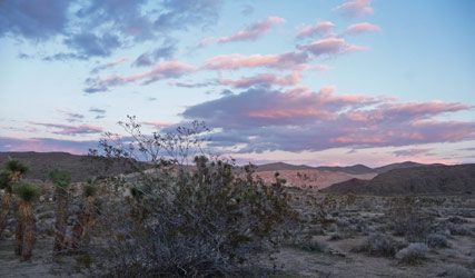
Later that afternoon as I was downloading the latest photos I looked out the window to see a gorgeous sunset forming. What a perfect end to our time in the desert!
In Part V, we'll be heading west to the coast to San Simeon, Big Sur and the Redwoods. Get ready for some wild windy weather and gorgeous coastal views.